
PAS128 Utility Surveys in Marlow
Enquire NowAt Specialist Surveyors, we deliver professional-grade subsurface mapping to help you secure your construction projects in Marlow SL7 1 and across the UK. Our work focuses on identifying the exact location of underground infrastructure to prevent the high costs and safety risks of service strikes.
By providing data-rich digital twins, PAS128 utility surveys assist you in establishing a defensible safety record while ensuring your groundworks proceed without structural or mechanical interruption.
Are PAS128 Utility Surveys Necessary for Your Site?
Implementing PAS128 utility surveys ensures you have a detailed risk assessment before machinery arrives to avoid damaging unmapped mains. This preventative step ensures you avoid public disruption and the massive costs of repairs while keeping excavation crews safe during intrusive groundworks.
We frequently assist with highway expansions and large industrial plots where the presence of high-pressure gas or electric lines is common. This professional oversight removes the danger of project downtime, ensuring that your building project stays protected from unplanned utility failures.
When is the Right Time for PAS128 Utility Surveys in Marlow?
Ordering PAS128 utility surveys in Marlow during the very early design stages is the best way to prevent project delays caused by hidden hazards. Getting this data before structural footprints are finalised identifies significant infrastructure bottlenecks, which allows you to re-route foundations without expensive late-stage changes.
It is also essential to refresh your data post-site clearance to confirm that marks remain visible for groundwork teams. Proactive mapping mitigates the risk of site fatalities and ensures your build remains legally compliant with national safety guidelines.
What is Included in PAS128 Utility Surveys in Marlow?
A modular suite of detection tasks is provided by PAS128 utility surveys in Marlow SL7 1 to yield a comprehensive digital map of your site’s subsurface environment:
Desktop Record Consolidation – Gathering and digitising statutory plans from providers to identify potential asset corridors before arrival.
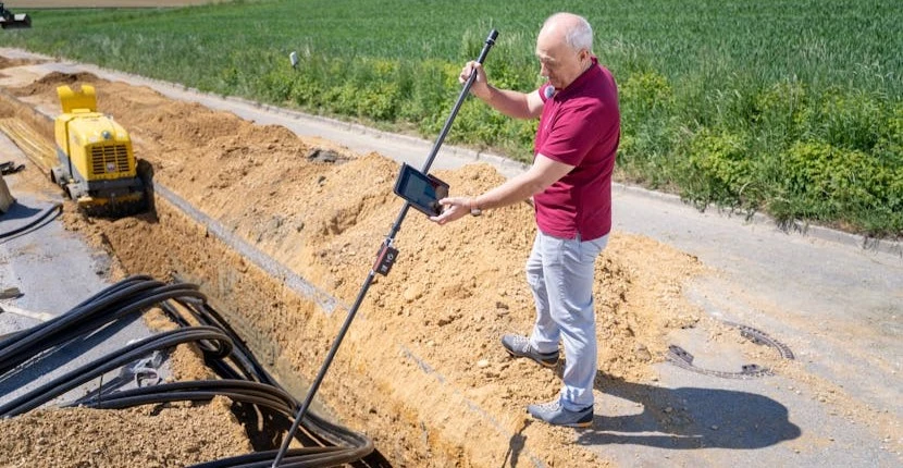
Electromagnetic Signal Tracing – Following the specific path of conductive assets like live power cables and metallic mains with high precision.
Ground Penetrating Radar – Emitting high-frequency pulses to locate non-metallic assets such as plastic pipes and hidden structural voids.
Topographical Data Layering – Merging subsurface findings with surface features using robotic total stations to produce a coordinate-aligned site model.
Confidence Classification – Assigning each detected utility a specific quality level rating based on the strength of the geophysical evidence.
What do PAS128 Utility Surveys in Marlow Cost?
The cost of professional PAS128 utility surveys in Marlow ranges from £850 to £5,500, depending on the site area and data complexity.
Costs are primarily influenced by the ground surface density, the number of buried assets, and the depth of 3D digital modelling required. Night-time traffic management or the requirement for manual trial hole verification to verify critical depths will also affect the final engineering fee for the resource allocation.
Contact Specialist Surveyors to get customised prices for getting utility surveys at your property.
How are PAS128 Utility Surveys in Marlow Executed?
Executing PAS128 utility surveys in Marlow begins with a careful site reconnaissance to locate signal access points like manholes and valves. Our surveyors utilise a combination of robotic total stations and LiDAR technology to record millions of points, which are then processed against National Grid coordinates.
This technical workflow orthorectifies raw signal data, removing the uncertainty of old paper records. This systematic sequence results in a verified digital twin, providing the spatial guide needed for construction.
Which Accuracy Levels Apply to PAS128 Utility Surveys?
Specialist technical categories are defined by PAS128 utility surveys to ensure that every asset is identified with the highest possible degree of certainty:
QL-D Record Review – The initial risk assessment phase focused on collecting and digitising statutory plans from providers.
QL-C Site Verification – A visual reconnaissance of the site to match physical surface features with the desktop records.
QL-B Geophysical Detection – The non-invasive phase utilising GPR and electromagnetic tools to define horizontal and vertical positions.
QL-A Physical Exposure – Confirmation of the exact utility depth and size through vacuum excavation or manual trial holes.
Digital CAD Mapping – Producing layered digital drawings that allow design teams to perform accurate clash detection.
How Quickly can PAS128 Utility Surveys in Marlow be Finished?
Completion of PAS128 utility surveys in Marlow usually occurs within three to five working days for standard development plots. We prioritise efficient data processing workflows, ensuring that digital drawings are delivered shortly after the fieldwork is finished.
For high-stakes groundworks, our engineers can provide on-site marking of hazards, which allows excavation teams to start working in safe zones immediately. This responsive service ensures that statutory compliance does not delay your construction schedule or project deadlines.
Are PAS128 Utility Surveys in Marlow Legally Compliant?
Strict adherence to BSI standards is how PAS128 utility surveys in Marlow SL7 1 ensure that your subsurface data is technically robust and legally defensible. This standard defines the mandatory accuracy levels required for a reliable map of the underground environment for engineering design.
Our work is also built around the HSG47 health and safety guidelines, which provide the definitive UK benchmark for avoiding subsurface danger. Following these benchmarks guarantees a verified data set that protects the client from measurement-related financial risks.
Which Sectors Require PAS128 Utility Surveys in Marlow?
Precision mapping data is supplied by PAS128 utility surveys in Marlow to a wide range of industries that depend on accurate site data to prevent accidents:
Civil Engineering Contractors – Requiring accurate data to protect staff during piling, trenching, and complex foundation installations.
Local Planning Authorities – Seeking verified site geometry to assess the impact of new infrastructure on public highways.
Property Developers – Utilising subsurface intelligence to manage the risk of service strikes during the subdivision of land.
Telecommunications Providers – Mapping the continuity of vast underground networks to support effective maintenance and fault finding.
Renewable Energy Firms – Identifying safe routes for wind farm cabling or solar array infrastructure to avoid existing mains.
Why Hire Professionals for PAS128 Utility Surveys in Marlow?
Relying on professional PAS128 utility surveys in Marlow from an accredited team provides an independent check of your site that provider maps cannot match. We provide an unbiased audit of site geometry, identifying subtle structural constraints or unrecorded services that internal teams might overlook.
Our professional oversight ensures that the instrumentation used is regularly certified, preventing the cumulative errors that lead to foundation failure. Investing in an expert survey optimises the build cycle, providing the technical assurance needed to build infrastructure safely.
How can You Book PAS128 Utility Surveys in Marlow?
Arranging for PAS128 utility surveys in Marlow starts with a site discussion to evaluate your specific project boundaries and data needs. Our engineers manage the full data capture lifecycle, from the initial provider record search to the final CAD verification of as-built results.
Securing this professional spatial record protects your project’s financial future, ensuring that your building plans are supported by precision-captured reality.
Contact Specialist Surveyors for a consultation to get utility surveys tailored to your organisation’s risks and responsibilities.
We cover Marlow (Buckinghamshire)